
111 the american grid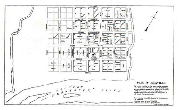
Founding plan of Knoxville, 1791
Hear an American voice in the wilderness, speaking to us from the year 1830. In an anonymous article in the American Journal of Science and Arts (as quoted by John Reps), the writer declares the need to...' embrace a science, for which I cannot find a name, for the good reason that among the nations from which we draw our language, no such science could be known. I mean the choice of position, and the planning of towns...'. Anonymous noted a great opportunity going to waste, in a time when so many towns were being founded. The grid bothered him, and he recommended just a little bit of irregularity to add some life to it. While anonymous was writing, hundreds of plans like this one were being laid out-a nation in a hurry, initiating the biggest wave of urbanization in the history of the planet. Knoxville, according to one of its citizens I once met, '...was built ugly, and stayed ugly.' But what clues to the American character does this manic geometry really betray? The consensus of opinion says that Americans are above all a commercial people, who like things practical and straightforward and rectilinear—'on the square'. Their grid, like their government, their decimal currency, or their manner of expansion by the methodical creation of new states, was the heir of Enlightenment rationality and Anglo-Saxon pragmatism, and it marked the dawning of something truly new in the world, an element of the 'New Secular Order' proclaimed on the Great Seal of the United States. In the colonial period, cultured gentlemen, working from royal charters and heading companies with considerable resources behind them, had given early America (both north and south) some remarkably creative and sophisticated town plans. Sad to say, that tradition was one of the first casualties of American independence. Left to ourselves, we quite rapidly abandoned any pretense of building amenity or character into our towns, and laid out nothing but simple grids. If these had so much as a central square, it was usually only saving land to build a courthouse or capitol on later. The model for all these plans would be that of Philadelphia. Before William Penn started his Holy Experiment, he already had some experience in colonization (in Perth Amboy, New Jersey), and he knew exactly what he was doing. Penn had been in London during the time of the Great Fire in 1666, and his Philadelphia plan is nearly the image of an unsuccessful one submitted by Richard Newcourt for London's rebuilding, with the same grid and quincunx of squares Memories of the fire were undoubtedly also behind Penn's prudent intention for his new foundation to remain spacious and open, with individual houses on large lots: 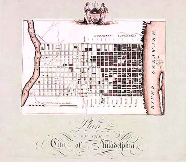
'Let every house be placed, if the person pleases, in the middle of its
plat, as to the breadth way of it, that so there may be ground on each
side for gardens or orchards, or fields, that it may be a green country
town, which will never be burnt, and always be wholesome'.
Philadelphia's early story seems to suggest the irrelevance of plans. Maps from the mid 18th-century, such as the one above, show a town that had very little to do with Penn's design. Houses and streets follow the blocks as originally surveyed, but they cluster exclusively along the Delaware, sprawling north and south of the original limits, following the necessities of trade and the desires of the inhabitants. Some of the blocks of the 'green country town' are already becoming densely built-up, split by cross streets and alleys, contrary to Penn's wishes. Most of the area of the plan remains entirely empty, and not a single house has yet appeared around the planned public squares; what is now Franklin Square was rented out for a while as a lumberyard. But Philadelphia is also an example of the persistence of plans. Over time, all those streets eventually took shape as Penn intended, while the squares were all reclaimed and landscaped. Philadelphia's tenacious plan became the seed for a great majority of American towns. Even its street names were influential. Penn's planners had sketched out numbered streets from the Delaware to the Schuylkill, and streets named after trees from north to south: Chestnut, Pine, Olive, Locust-Arch and Race Streets were originally Mulberry and Sassafras. The two axial, defining streets, Broad and Market, met square in the centre of town. Under the tutelage of a Pennsylvania-born mayor, St Louis laid out new streets in the 1820's after the Philadelphia pattern; only the names of the trees were different. The new houses the Americans were building in that old Creole town echoed the styles of Philadelphia too. If Philadelphia's grid would be the template for an urban nation, one thing was consistently omitted: the amenities, the parks and squares, the concern for siting healthy and pleasant places for people to live. Between the era of gentleman colonizers and the era of a young federal democracy, something had happened, a profound change in the way people looked at the world around them. Few in the past had ever been shy about exploiting nature, given the opportunity, but that nature had always been perceived as holy and alive. Though no colonizers were ever as pious as America's, their religion was a matter between God and the individual soul. To a man like Cotton Mather in the early days, creation had been at least a haunt of demons and an abode of mystery. Now, in the secularized cosmos of the Enlightenment, that creation became a blank page. America meant to fill it up. And its chosen weapon was one of the most far-reaching and philosophically radical pieces of legislation ever passed by Congress, the Land Ordinance of 1785. The future of all the western lands was determined at a stroke. Surveyors would be sent out far into the wilderness to fix meridians and base lines; from these, half a continent would be arranged into six-mile square townships, each divided into 36 square 'sections' of 640 acres, then sold at a fixed minimum price of a dollar an acre. The mind behind this audacious scheme, the author of the Land Ordinance and of our National Grid, was Thomas Jefferson. The idea of the township goes back at least to Saxon England. When the Venerable Bede first used the word in writing, in his 9th-century Ecclesiastical History, it was defined not as a division of land, but a community: the population of a village, along with its homes and fields. As such, it was a basic political unit throughout English history, and the first colonists in New England used it for the organization of their settlements. We can see the beginnings of abstraction-the transition from a township that was a human commonwealth to one that meant only boundary lines drawn on a map- in a 17th-century Puritan document called The Ordering of Towns. Here, the anonymous Puritan planner clearly intended to keep up the medieval village organization; no one would be allowed to live more than 1 1/2 miles from the central meeting house. But he goes further, anticipating Jefferson by expounding a plan for establishing six-mile square townships, each with a meetinghouse at the center, surrounded a village of 'house lots', surrounded in turn by the common lands, farm lots and wood lots. Jefferson, coming from the Virginia plantation lands where village organization never really took hold, most likely never saw The Ordering of Towns, but he would have been familiar with rural affairs in both England and New England, as well as the new township grids being laid out in the 'military lands' of New York and Ohio for land grants to Revolutionary veterans. Nor would it have been lost on Jefferson that for the dour zealots of Massachusetts, village organization had been not a mere reflex of cultural continuity, but most importantly a means of social control. Perhaps because of this, there were to be no attempts to force the creation of village communities in the new dispensation, despite some complaints from New England congressmen. People on the frontier would live where they pleased. They didn't waste any time. The first seven ranges of townships in southeast Ohio, around Marietta, were surveyed by 1786 for a syndicate of Massachusetts speculators called the Ohio Company; from there the sensible new pattern took off, overcoming all resistance. Rare exceptions to the grid would persist in many places: the Scioto valley in southern Ohio, most of Kentucky and Tennessee, the old French and Spanish-settled areas in Missouri and Louisiana, parts of coastal California and eastern Texas, and such anomalies as Big Rock Township in Kane County Ill., near Chicago, where Welsh settlers bought land communally and distributed it among themselves in the 1840s. Everywhere else, even in the Rocky Mountains where a three-dimensional nature would seem to laugh at surveyors' lines, America submitted to the confident geometry of its new masters. [exceptions to the grid: in parts of the nation settled before 1785, the old surveying method of 'metes and bounds' is still in use; here, streams, old roads and monuments such as trees or boulders can serve as boundaries, and distances are measured and aligned with the use of a compass. This area includes all of New England, and parts of New York, Pennsylvania, New Jersey, Maryland, Delaware, Virginia, the Carolinas, Georgia, Kentucky, Tennessee and Texas. Wherever it is in use, surveyors note it gives rise to considerable confusion and litigation.] Not for the last time, America had made a decision that favored individual liberty at the expense of community. The adoption of the grid marks the beginning of a divide between government and organic reality that continues to this day. Throughout the world, previous efforts at colonization had been based on the founding of cities, from the Greeks and Romans to the Spanish lands in the New World settled under the Law of the Indies, not to mention the religious experiments and royal proprietors of British North America. Now, a system was in place that made the earth a blank slate; the villages, towns and cities of the future would be left entirely to chance and speculation. The settling of the west would proceed on separate, parallel tracks: land was distributed to families by a process governed from Washington and shaped by the National Grid, while towns and main roads grew up freely and organically; the two systems never really meshed. Rectilinearity became a national reflex; on the frontier, people came to consider anyone who did not build his house parallel to his property lines as eccentric, not 'on the square'. Back in Boston, Charles Bulfinch came home from Europe in 1794 and began an elegant British-style residential terrace called Tontine Crescent; when it was half finished, his backers lost their nerve and insisted on doing the rest in a straight line. Whatever distinction American city-building possessed in colonial times disappeared almost completely with the establishment of the republic. In all the older towns, commercial pressure cheapened the Baroque or medieval plans left from the original colonies. Throughout history, from Hippodamus to William Penn, grids had been only the background to sophisticated yet simple design systems, where amenity and practicality were held in a satisfying balance. Now, in the New Secular Order, continuity with the past was forsaken; shorn of its embellishments, its open spaces, boulevards and focal points, the grid became a radically new type of plan, one devoted to no finer purpose than facilitating speculation in city land, and religiously excluding anything that might hinder speculation. ...That a city is to be composed principally of the habitations of men, and that strait sided, and right angled houses are the most cheap to build, and the most convenient to live in.' So reads the report of the commissioners who presented New York's plan of 1811, the plan that Henry James in The American Scene called the city's 'original sin'. It was Jefferson's vision translated to urbanism, a bold plan that covered all Manhattan Island-then over 80% farmland-with the pattern of numbered streets and avenues we know so well today. It was a plan breathtaking in its monotony, showing no consideration for the lie of the land, for amenity, or even for diagonal traffic. If it had been followed to the letter there would today be no Central Park, no Times Square-not even a Broadway above Union Square. Right-thinking New Yorkers praised it, because it would help business. A city that was booming already, and looking fair to boom forever, proclaimed it was not ready to sit back and enjoy life just yet. New York wanted more. The commissioners were not barbarians. Along with several squares and parks, their city plan included the 'Parade', a green over 44 city blocks, by far the biggest open space ever proposed in this era. To sell the plan to the hard-nosed businessmen who would decide its fate, they rationalized this as a ground for military drill. The Parade was to have been located between 14th and 34th, but that land was soon gobbled up by speculators, along with the marketplace proposed for the East River shore between 6th and 10th. Following what had already become the common American practice, the city eventually found itself unwilling to meet the speculators' price for the land, and the plan was changed. Other cities' efforts proved less thoughtful than New York's. In Philadelphia, north and south of the original city, the grid clattered on continuously; Dickens in his American Notes called the city 'distractingly regular...After walking about for an hour or two I felt that I would have given the world for a crooked street'. New cities on the frontier tell a depressing story of missed opportunities. Chicago's numb grid, laid out in 1830 by James Thompson, was like so many others a pure act of speculation; the plan had been commissioned by the Illinois and Michigan Canal Commission. In 1840's San Francisco, a difficult, magnificent natural site was rationalized into a primitive grid designed by an Irish tavern-keeper. In creating the perfect level ground for developers, cities were not content with scrawling bland grids on paper; the process often entailed considerable violence to the landscape. Economic necessity meant the wanton destruction of all natural features, to create as much flat ground as possible at the center; it resulted not only in projects such as Boston's colossal landfill schemes, but also levelling hills. Manhattan offered some quite varied topography before the city-builders flattened it. Hill-cropping was also common in Boston, where Beacon Hill had nine feet taken off its top before its development. Hill dirt went to fill inlets, ponds and streams (which were of course often stinking nuisances) like Boston's ragged shoreline, or Jones Falls in Baltimore. The essence of what historian Sam Bass Warner has called the 'Private City' is captured in these plans, and it explains a monotony that was largely intentional. Of the inner circle that commissioned and adopted plans like these, most members would have some holdings in soon-to-be-developed land. Any amenity, such as a square or boulevard, would influence the growth of the city and hence favor one man's investment over another's-the one thing that government, according to the reigning liberal ideology of the times, must never, ever do. Like the National Grid, a town plan was supposed to be democratic; at least in the beginning, each parcel on it was theoretically equal. It is very doubtful, however, that any town plan ever really met this intent. Simply creating an intersection of 'Broad and High', or 'Center and Main' on the plan would give everyone a good idea of where the '100% corner' was likely to take shape, and after that the biggest players could always influence future development simply by where they sited the first big hotel or business block. Everywhere on the frontier, city-building was subject to extreme competition; surveyors plotted hundreds of towns that never developed at all, or struggled for a while and then disappeared. It reflects badly on Americans that amenity never seems to have been a factor in attracting investors and settlers; the vast amount of surviving promotional literature for new foundations might mention 'healthful sites', but the emphasis is always on prospects for future growth, and there is no evidence that well-planned foundations did any better or worse than the most basic. The profit motive determined not only the actions of city founders and settlers, but also those of the young cities themselves. Many of these depended more on the sale of lands than on taxes; Albany, as late as 1811, was getting 60% of its budget from land sales, and much of the rest from services, such as the ferry over the Hudson. Already, city expenses were increasing dramatically, and there was always strong pressure to keep taxes down. If one administration in the early years resisted the temptation to sell off open spaces and common lands for quick profit, its successor might not. Reaction against gridmania would only begin in the 1830's, in the theories of Andrew Jackson Downing, but its influence would be limited to landscape gardening and a few choice planned suburbs; the National Grid continued to march on across the plains, and men still founded and expanded cities in the same tired pattern. Hints of increasing maturity would have to wait until after the Civil War. In 1873, a landscape gardener named H. W. S. Cleveland, later to become famous for his great Minneapolis park plan, could complain: '...all the naturally beautiful or picturesque features of the place have been destroyed or rendered hideous in the effort to make them conform to a rectangular system, as if the human intellect were as powerless to adapt itself to changing circumstances as the instinct of insects, whose cells are constructed on an unvarying pattern'. A perfectly valid criticism, but even then it would still be a long time before anybody listened American local history often dips deeply into the absurd, but it offers few stranger tales than that of the Circleville Squaring Company. Circleville, Ohio was founded in the center of an ancient temple, a set of concentric circular mounds built by the Hopewell people in the 11th century. The first settlers levelled the earthworks, as they did with so many fascinating monuments of the Mound Builders in the Ohio valley, but with a spark of imagination rarely seen on the frontier, they laid out the streets over their courses, so that the centre of town was a circular plaza, surrounded by a circular boulevard one block out. It did not last. Perhaps frontier builders' talents did not extend to joining walls at an angle, or else the arrangement was attracting some dark telluric forces to jangle the pure Protestant souls of the Circlevillians. Whatever the reason, they just couldn't stand it. In the 1850's a group of local businessmen started the Circleville Squaring Company with the support of the mayor and council. Their purpose was to erase all traces of circularity, and they worked tirelessly to complete America's first urban renewal plan, purchasing and levelling the center of town, replatting the streets along a grid and selling off the new lots. Unaccountably, the only thing they did not do was rename their town Squareville. John W. Reps, the devoted historian of early America's city-building, got it just right: 'The gridiron plan stamped an identical brand of uniformity and mediocrity on American cities from coast to coast'. The fertile American imagination had already achieved much in literature and the arts, particularly architecture, but faced with tremendous opportunities at the beginning of a great age of city-building, it failed to hold its own against an ethos of rapid development and speculation. 
Circlevillians of today seem to regret their
ancestors' fit of madness, and they have incorporated this view of the
old days in their city seal; it shows the octagonal courthouse that
once occupied the center. The original circle, typical of the
mounds built by prehistoric peoples in the Ohio valley, was
1100 feet in diameter. A processional avenue connected it it to a
900-ft square enclosure. They plowed that up too.
|
|

|
