228 the magic corridorImagine a pie, and cut one slice—the fattest one, with the most cherries in it. This is the segment of the city the wealthy have chosen, spreading outwards from the center. As it expands with each generation, residential sections reach further into the periphery. Commerce, in the form of the most prestigious office blocks and swank shops, encroaches from the other end. This is how Fifth Avenue became the way to the promised land in New York, starting in wealthy neighborhoods around Washington Square, and finally reaching the upper east side. In Boston, the slice is an axis through Beacon Hill, the Back Bay and Brookline; in Baltimore, it runs northwards, straight up Charles Street. London works the same way, and has for about a thousand years—the tourist map or Underground map of 'Central London' they hand you is really a map of the West End. This rule doesn't work 100% of the time. San Francisco's difficult terrain makes its historical settlement patterns different from those of any other city. Sometimes the pattern can be interrupted, as in Chicago, where the original magic corridor went due south until about 1910; then, it ran up against undesirable patches of industry and slums, and well-off Chicagoans began to favor the North Side neighbourhoods along the lakefront. Continental cities, on the whole, do not show the pattern so strongly. The older the city, the more complex its morphology is likely to be. In Florence or Rome, every point of the compass will show a neighborhood that was the height of fashion in a distant century. But even in the Middle Ages some commercial cities were beginning their magic corridors, as in London's West End drift, or Bologna's. Paris is a special case, with a remarkable continuity of state efforts to encourage such a corridor along the 'Grand Axe' west of the Louvre that began with the Place Vendôme under Louis XIV, and continued with the building of the Place de la Concorde, the Arc de Triomphe and Baron Haussmann's promotion of the 16th arrondissement, all leading towards the development of La Défense today. The magic corridor in America was first analyzed by the Chicago sociologists Homer Hoyt and Robert Park, in The Structure and Growth of Residential Neighborhoods in American Cities (1939). In America, the pattern is usually the same, whether the city's adolescence occurred in the 1790s or the 1920s. Los Angeles's Wilshire corridor, out towards Beverly Hills, is formally the same kind of axis as Boston's, however much the scenery along the way may differ. This corridor of the Miracle Miles and Millionaires' Rows has been a constant feature of American cities from the beginning, an obscure Iron Law of the Anglo-capitalist settlement. Here's how the magic corridor grew in one city: 
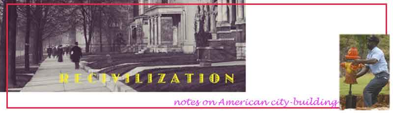
In Cleveland, from the beginning, people who could afford it lived to the east of Public Square (1), away from the commercial district and the industry along the Cuyahoga River. Euclid Avenue (the old Buffalo Road) became the center of the first fashionable residential district (2). Note thedotted contour sline paralleling Euclid just to the north, marking a slight ridge that gave the street's residents a view out over Lake Erie. The long blocks along Euclid on this 1904 map were the famous 'Millionaires' Row' of the city's industrial heyday after the Civil War. While Millionaire's Row was at the height of its glory, the stretch of Euclid further east (3) developed rapidly, with upper middle class residences, apartments and shops, both on the Avenue and in the new East End district (now called 'Hough') to the north of it. Cleveland's major uptown business district, with five theatres, shopping and elegant apartment hotels, grew up around Euclid and East 105th Street (4). As early as the 1880's, Cleveland's business elite had been donating land and encouraging the concentration of cultural institutions around what is now Wade Park and the University Circle district (5). After about 1910, the old Millionaires' Row and its florid eclectic architecture began to seem dated. Traffic and commercial uses encroached; for the first time, the smart shops and even office blocks were appearing east of the Square on Euclid. Gradually, the elite pulled up stakes and relocated further east, skipping already-developed upper Euclid and building upon the 'Heights' (6) up Cedar Hill (now Cleveland Heights). Very soon, the white spaces to the south on the map would be developed by the Van Sweringen brothers as Shaker Heights. The magic corridor typically expands in breadth as it grows outwards. Ever since, Cleveland's magic corridor has followed this route eastwards. There's a cautionary tale here; if a city doesn't take care of itself, the areas left behind by the wave of fashion can decay rapidly. The former Millionaires' Row is now a nondescript, low-value commercial district, while upper Euclid passes through some of the city's worst slums. Redeeming it is currently Cleveland's number one redevelopment priority. |
|
|
