
110 origins of the grid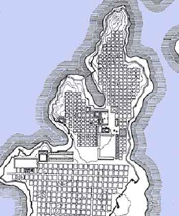
Hippodamus' grid plan, employed
in the rebuilding of his home city of Miletus after its destruction by
the Persians, c. 480bc.
We associate it with modern civilization, and rigid order, but in truth urge to rectangularity has appeared in peoples all over the world, in all times. Neolithic farmers in western Europe often laid out their fields in rectangles, separated by straight rock walls. Ancient ruins as far back as the cities of the Indus Valley, or Harappan civilization, c. 2600bc suggest aregular grid of streets. Before the scholars discovered more about the achievements of ancient peoples, credit for inaugurating the art and science of urban design was generally given to the Greeks. The first planner to leave his name, Hippodamus, was a long-haired philosopher from Miletus, that famous city of philosophers on the coast of Asia Minor. Hippodamus worked on the rebuilding of his home town after a sack by the Persians, and he went on to lay out Piraeus, Athens' port, as well as new Greek colonial cities in Italy, all on strict grid plans. The Romans learned it from the Greeks, and over seven centuries they learned little else. The West's first methodical imperialists started with rectangular, grid-planned army bases, or castra, and they adapted the form to the hundreds of towns they founded across their empire. These can still be traced in the street plans of countless towns today, stamped out of the same cookie-cutter from Chester, England to Diyarbakir, Turkey. Historians often compare the Romans and the Americans—not a comparison we should necessarily find flattering. But for them, as for us, expansion and conquest were inextricably bound up with land, the most valuable booty to be had. Some of it went to the veterans who had made the conquest possible, but the greater part always ended up in the hands of the Roman elite, for speculation and for consolidation into massive private estates. Rugged Mediterranean landscapes do not often lend themselves to large-scale rectilinear surveying, but wherever nature gave them the chance, in the broad Po valley, recreating the grids of the vanished Terramare people, or in the flat coastal plain of Apulia, the Romans designed landscapes of long straight roads and square fields where any American might feel at home. 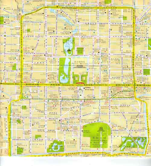
A map of central Beijing.
The Forbidden City stands at the center. The northern and southern gates do not align directly, to keep evil spirits from passing through the city easily. The ring of boulevards marked in yellow show the limits of the original foundation and its southern addition under Mongol rule. Inside these is a grid of long straight roads, wider than Paris boulevards. They are the macro scale of Chinese urban life; the micro, which often comes with considerable intimacy and charm, is represented by the alleys, or hutongs, that run between them-too many to show on this map. 2200 years ago, the plan of the first Han imperial capital, Chang'an, looked much the same as this. And so did every other Chinese city founded over the next twenty centuries. 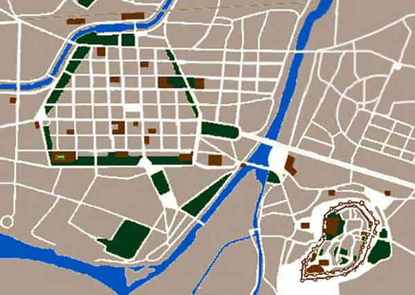
Plan of Carcassonne, France. In the 13th century, when Louis IX rebuilt this
fortress city, the military key to his new conquests in the south, he
left the old fortified town (lower left) as it was. For its modern
expansion (top right), only something modern and up-to-date would
do—a grid, with a market square at the center.
The truth is, wherever new lands are to be parcelled out or new cities founded, western peoples have generally hit upon the grid. The most convenient plan for the surveyors, it is also wonderfully easy for buyers and sellers to understand and use. We tend to associate the Middle Ages with crooked narrow streets and picturesque lanes, but even then, whenever something new and planned was undertaken the right angle came into its own—as in the medieval new towns or bastides scattered all over southern France, each with a market square and a church at the center of the grid, or royal foundations such as Aigues-Mortes in Provence or L'Aquila in central Italy. With the coming of the Renaissance, European town-builders continued along much the same lines, although they often embellished the simple grid with radial boulevards and stage-set piazzas. With this background, it is entirely understandable that grid-planned towns should appear in the colonies of the New World, and they almost invariably did, whether the colonialists were Spanish, French or English. |
|

|
