218 allegheny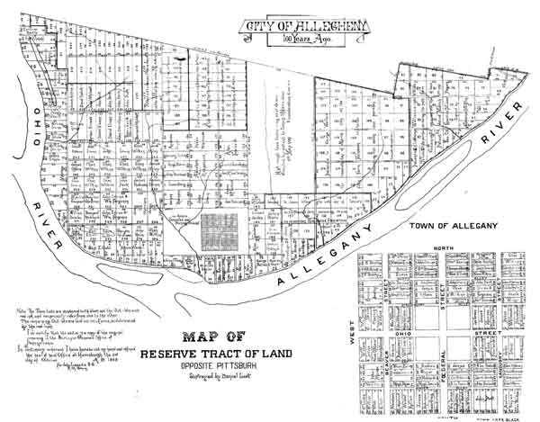
The most provocative and useful idea in design from all the new cities
founded on America's frontier happened more or less by accident.
For some 170 years it managed to survive, again more or less by accident. In
the 60's, some of our cleverest minds in planning and urban renewal
combined to trash it. Next time you're in Pittsburgh, take a stroll
over to the North Side to see what's left.
In the new settlements across the mountains, early Americans adopted a common pattern for planning new towns, involving three different types of land. At the center, the land syndicate would lay out a core of regular town streets, and mark out building lots for sale. Beyond the core, large areas would be staked off as 'out lots' for purchasers to farm, while they waited for future development to allow them to sell at a good profit. Often these out lots would be intentionally made the size of city blocks, to anticipate growth and make the development process easier. The third type of land was common land, destined for the new municipality to keep—at least for a while. Gradual sale of common land would help support the city government in the early years, when tax revenues were few. In theory, towns might have conserved some of their common land, for parks or other public uses. Few ever did, outside of saving a public square from the original plan. One town, perhaps only one, decided to keep most of its common lands as a park, and the result is a unique triumph of design that survives in part today. Allegheny, Pennsylvania was founded across the river from Pittsburgh in 1788, and grew up as a kind of Brooklyn to the larger city until its annexation in 1907. Now it's Pittsburgh's North Side, the home of Heinz ketchup and the Pirates' new ballpark. A frontier surveyor named David Redick gave Allegheny its unusual plan, which was approved for the State of Pennsylvania by Benjamin Franklin himself. Redick did not put the common land on the edge of town—he laid out the town in the middle of it. At the center was an open square (a 'diamond', as they like to call them in western Pennsylvania), with a greater square of 36 city blocks surrounding it. Completely enclosing that was a spacious rectangular common, and out lots beyond the common were sold for residential districts. It worked out brilliantly. A thriving city center grew up inside the common, which was landscaped as a park in 1867, and its people built elegant townhouses around the edges. For most Alleghenians, going to work meant a short stroll through the park. Allegheny took some hard knocks from the grim industrial ethos of old Pittsburgh: two quadrants of the central square were used for public buildings, while some parts of the common were sold off, and a railroad run through one corner of it. Urban renewal brought worse in the 60's, when nearly all of the central town was demolished, and replaced by office blocks and a poorly-designed shopping mall that has since failed. But the homes on the periphery survived; some of these, on the 'Mexican War Streets', provided the ground for Pittsburgh's first spontaneous revitalization in the 60's, an inspiration for other efforts around the country. Like Savannah, Allegheny shows us how quality endures, how urban design can give not only grace to towns and neighborhoods, but stability and continuity. Good residential architecture, of course, counts even more, in keeping residents and attracting new ones, but design amenities do make a difference. Examples from American cities are rare only because good design is so rare-but think of Manhattan. The creation of Central Park anchored the middle and upper classes around the center of the island; if it wasn't there, migration patterns would have continued as previously, with the poor chasing the rich ever northwards. The business district that was fated to grow up around midtown (because that is where the rail stations were located) would likely be surrounded by slums today. 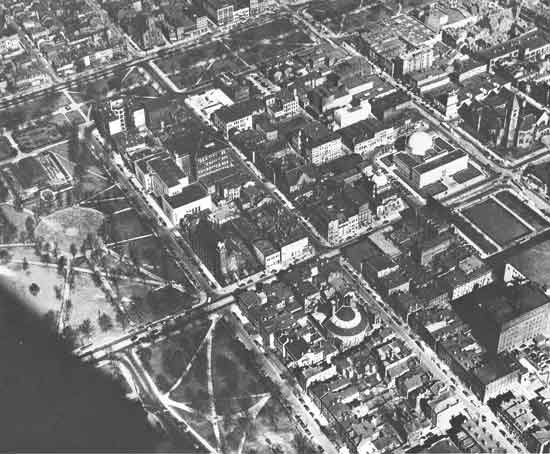
Allegheny center and part of the Common in the 50's, looking NNE (the
parkland is visible at the top and left; the four blocks of the central
square at right. Allegheny's city fathers had already betrayed the
original plan by building on three blocks of the square, including a
courthouse, a market, and —the building with the big
dome—the Buhl Planetarium). Almost all the buildings you see
inside the common would soon be wantonly destroyed by urban renewal.
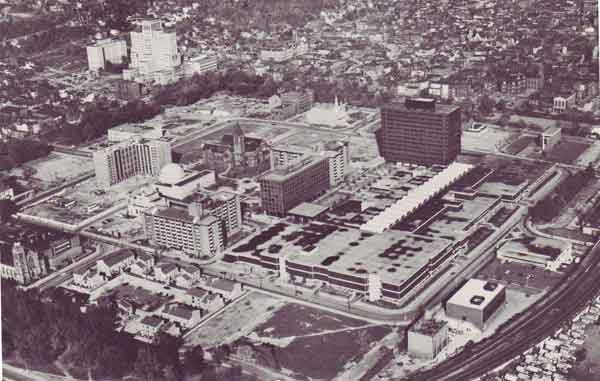
Allegheny Center after urban renewal.
|
|
|
